
McGown house and Fort Fish, detail, by John Joseph Holland, 1814
We noted earlier how the McGowan’s Pass gatehouse radically changes shape as we go from one illustration to another. Stranger still is how the McGown house up on the hill seems to be re-imagined in each depiction.
This lovely view on the left, by John Joseph Holland, circa September 1814, is probably the most authoritative version. The house was still fairly new, having been rebuilt from the ground up in 1790. It doesn’t look anything like the tumbledown four-room abandoned farmhouse described in 1846. In fact, it looks like a grand mansion that got enfolded into Hampstead Heath. Holland may be idealizing the house and foliage—perhaps to brighten and balance this green-and-brown study of earthworks fortifications?
 A couple of months before Holland’s watercolor, we have this preliminary drawing of the region, showing the proposed fortifications along the Pass. The rendering, probably by James Renwick, Sr., is amateurish, with bad sense of perspective and proportion. The McGown house is much humbler here, a generic skull of a farmhouse, not worth spending any detail on. Does the illustrator scant it because it’s non-essential, or is this just a bad drawing?

Hayward lithograph, from Valentine's Manual 1856. Gatehouse and McGown farmhouse from the northwest.
Moving along here, we have a mid-1850s Hayward lithograph. This was printed in Valentine’s Manual for 1856, when the plans for Central Park had aroused public interest in McGowan’s Pass and the old forts. While this must be a copy of some earlier illustration(s), it may also be a compromise between the two views above. The house is again a modest two-story farmhouse, minimally rendered; except we have this odd cornice-thingummy in the middle of the roof. It seems to be an attempt to draw the front gable that we see in Holland’s detailed rendering.

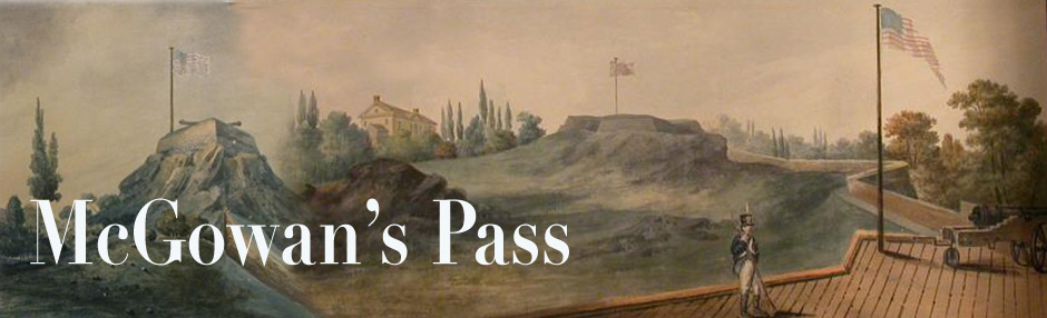
Fanciful 1893 depiction of the Pass, from 1893 "Felix Oldboy" book of reminiscences.
Now we get to 1893, and this imaginative reverie of McGowan’s Pass as it might have looked in 1814 (if it were in a travel guide, perhaps, describing the South Tyrol). Here the McGown house is minimal indeed. No gable or cornice or even shrubbery. It is however a very large house, larger than the Holland version, if we take the perspective literally. The illustrator apparently drew the farmhouse out of his head, using basic geometric shapes and not worrying about accuracy. He placed it accurately across the road from Fort Fish (which is well done), but the house seems to be perched on the very edge of the Post Road (East Drive). Â It looks like the shopper’s model for a 1960 split-level tract house.
Some interesting touches you don’t see in the earlier illustrations: 1) the railings along the Post Road at left, as it descends toward Harlem Creek. The dangerousness of this road was indeed an issue in the early 1800s; in the City Council Proceedings, we find the aldermen voting to provide money for building railings along here. 2) The illustrator shows the Post Road forking off to the left, and the post-1860 East Drive switchback going through the gatehouse on the extreme right*. This anachronism must have confused hordes of amateur historians in the 1890s.
*The full image, with further snarky commentary, is in an earlier post!